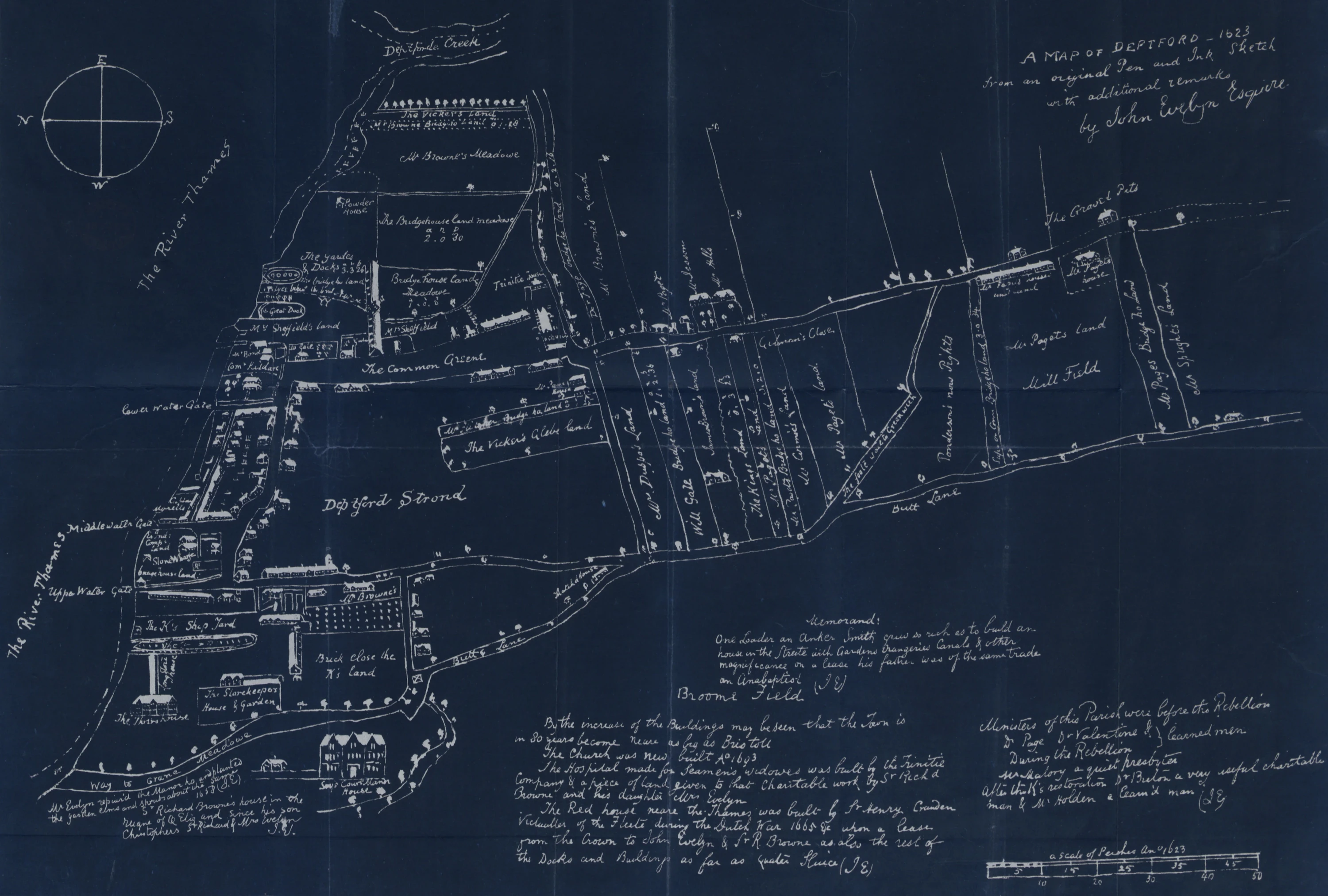
Made for entirely practical reasons, the 1623 map was never meant to be a historical document. It became one anyway, thanks to a certain diarist and a marriage.
Why is this map important?
This is the earliest existing detailed map of Deptford. It captures the town at a pivotal moment: the Royal Dockyard at full capacity and the East India Company building ships on the waterfront. For anyone trying to reconstruct what Deptford Strand, Butt Lane, or St Nicholas looked like before the town was swallowed by London, this is where you start.
Who made the map?
We do not know. The 1623 sheet is an anonymous manuscript. What we do know is who owned it later. John Evelyn, the diarist and local landowner, kept the map and later annotated it in his own hand. The surviving copy sits in the Evelyn Papers at the British Library.
So who drew the original? The likeliest hand is a working surveyor, paid to sketch Deptford for someone who needed it: the Brownes of Sayes Court. In 1623, Richard Browne graduated from Oxford. He may have commissioned the map, but his father, Christopher Browne, is just as likely a candidate: he was already running the estate and handling its paperwork.
And how did the sheet end up with John Evelyn? Through marriage. Evelyn married Richard’s daughter, Mary Browne, in 1647. Her dowry included the lease of Sayes Court. The map could have come with the rest of the Browne papers. The original manuscript stayed with the Evelyn family, eventually reaching the British Library. Around 1800, an engraver named Henry Mutlow made the first printed copy. Nathan Dews published it in his History of Deptford in 1883.


Evelyn treated the map as a logbook. In the early 1700s, he used the margins to note what had changed since 1623: repairs, ownership, new institutions, dockside building, clerical turnover. He noted, with some satisfaction, how far the town had come: “By the increase of the buildings may be seen that the town is in 80 years become nearly as big as Bristol.” It was a stretch: by 1700, Deptford had around 12,000 people, while Bristol had 27,000.
What kind of map was it?
If you bought a map in the 1620s, you were usually buying something general: county maps and atlases, like Saxton’s survey (published 1579) or Speed’s Theatre of the Empire (published 1611–12). Great for seeing counties and towns in miniature. Useless for the day-to-day geometry of a single riverside place.
For close-up detail, people relied on estate maps made for private use. They were working documents first, artworks second. The Deptford sheet feels closer to that tradition than to anything you would have bought at a bookstall on old London Bridge.
The Brownes almost certainly commissioned this map for practical reasons: to record what they owned, where the boundaries sat, and who owed them what. It notes property boundaries, street names, wharves, and acreages: the kind of detail you need when you’re managing an estate, collecting rents, and keeping track of rights of way.
Take the fields between Butt Lane and Church Lane. Each strip is labelled with an owner’s name and an acreage in the old format: acres.roods.perches. “The Kings Land 0.3.23” is three roods and 23 perches of Crown land sitting between private holdings. On the neighbouring “James Brown’s Land,” a builder called Thomas Lucas would put up a new street in the early 1700s. It’s Albury Street now, and the Georgian terrace is still standing.
How big was Deptford in 1623?
Rather than explain what the map shows, let’s borrow a better pair of eyes. In The Reckoning, Charles Nicholl gives the clearest picture of the scale. Deptford Strand covered roughly a quarter of a square mile, from Sayes Court to Deptford Creek along the river, and inland as far as the road that is now Evelyn Street. The map shows around a hundred dwellings in total: substantial detached houses facing the Common Green, and tightly packed tenements in the dockside alleys near the waterfront.
Our route is basically a cross-section. We start at the Upper Water Gate on the Thames edge, where Deptford’s working day begins, then cut inland to the Green: the village’s open ground. From there it’s a short stroll to St Nicholas and its churchyard, the parish landmark, before the path turns towards Butt Lane, which had none of the commercial allure of a modern High Street: as Evelyn could have told you, having owned some of them, it was all fields.
So, can you navigate Deptford with this map today?
Roughly. Watergate Street is still there, the curve of Borthwick Street is still there, Deptford Green is still there, and Stowage still hugs the churchyard. Church Street and High Street follow the same paths as their predecessors. Crossfield Street still runs diagonally towards Greenwich exactly as the “Foole way” did.
But aside from St Nicholas, none of the landmark buildings match. Sayes Court and Trinity Almshouses were demolished. Master Shipwright’s House, the oldest surviving building of the Royal Dockyard, was built almost a century after the map was produced. The dockyard itself has been a barren ground awaiting regeneration since 1997.
From Georgian and Victorian urban development to wartime damage and municipal-led devastation of the 1960s and 1970s, Deptford kept changing. What the 1623 map turns out to be is a record of geometry: how a town was laid out and where roads went. That kind of information is harder to erase than brickwork. Four centuries of demolition and rebuilding left the skeleton intact. You just have to rotate the map first.
References
- Map of Deptford in 1623. From The History Of Deptford by Nathan Dews
- Map Of Deptford, 1623. Ideal Homes: A History Of South-East London Suburbs
- Kent: Deptford, 1623. Catalogue of British Town Maps
- The Reckoning: The Murder of Christopher Marlowe. Charles Nicholl
- Deptford, in Old and New London: Volume 6. Edward Walford
- A Selected List of Estate and Parish Maps up to 1850 in the Bodleian Library. Nigel James
- John Evelyn. Catalogue of English Literary Manuscripts 1450–1700
- Timeline. Sayes Court Garden
- Atlas of England and Wales, 1579. The Royal Collection Trust
- John Speed proof maps. Cambridge University Library
- Estate Maps. The National Library of Wales
- Convoys Wharf. Post-excavation assessment report and updated project design. Museum of London Archaeology
- Sayes Court Manor House backfilled. London’s Lost Garden
- Neglected History of the Greenwich Riverside. Mary Mills
- The Lost Village Center Of Deptford. Old Deptford History
- Building Layout Change from Union St to Albury Street. Old Deptford History
- History of Albury Street Part 2. Old Deptford History
- Deptford Trinity Almshouses. London Remembers
- Copperas in Greenwich and Deptford. Greenwich Industrial History
- Deptford Bridge. Townscape and Visual Impact Assessment. Emma Shaw, Philip Clemens
- Upper Watergate Street. The oldest street surface in London? Glyn Harries
- The Common Greene: Reading Deptford History through Peter Linebaugh. Transpontine
- Isaac Loader. Book Owners Online
%27_(11166594844).jpg)
Support my work by subscribing to Hypertextual, a newsletter about science and big ideas.